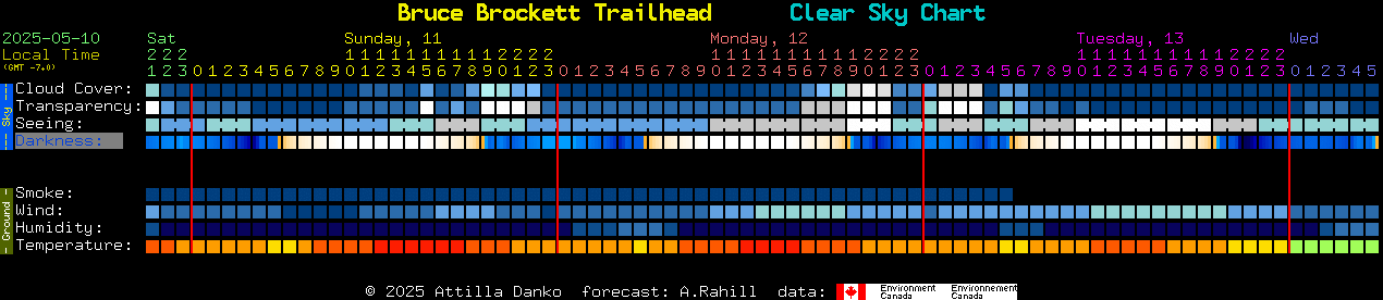
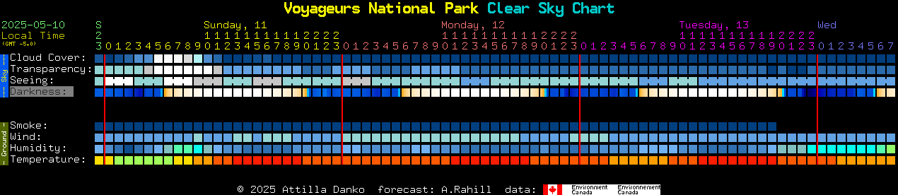
Observing Tools


Astronomers
of
Verde Valley


Home Club Calendar Contents Astronomy News Observing Tools Web Links Club News Articles Astrophotography Site Search Feedback Picture Credits Mission & Bylaws


Seeing is Believing

Aids to Observation for Amateur Astronomers


Star Charts Sky Maps Clear Sky Clocks   Topographic Maps

Star Charts

SFA Star Charts

Click Here to download free printable star charts in PDF format from the SFA Observatory.

For best results you may want to try these printing instructions for the PDF files.

To view and print these star charts you will need the free Adobe Acrobat Reader.

These charts were made using Microsoft Excel with Visual Basic macros that resize and label the dots. Many students contributed to this project that took years to complete.

The author, Dan Bruton, is a professor at Stephen F. Austin State University and works at the SFA Observatory.

Let Dan know what you think about the SFA Star Charts. 
Feel free to
email Dan Bruton your thoughts or questions about this project. 
He welcomes feedback.

Sky Maps

Monthly Sky Maps from Skymaps.com

Click here to download  free monthly editions of a sky map from this source.

For Iridium Flare, ISS, HST, Minor Planet and Comet viewing, check out Heavens-Above.com

Clear Sky Clocks

These Clear Sky Clocks attempt to show at a glance the forecasted visibility factors (clarity and darkness) for a particular observing site over the next 48 hours.

The display is designed specifically for amateur astronomers. The input for these panels comes from  weather models run by  the Canadian Meteorological Centre. They run a weather simulation every four hours. The numerical output feeds the panels below but can also generate forecast maps that look like satellite pictures.

You can read the clocks just as they are on this page. However, clicking on a clock will bring up a "legend page" with supporting information for the clock and live links to other data. To see a forecast map click on the 'cloud', 'transparency' or 'seeing' block on the legend page. You can choose to animate the forecast map and see the weather pattern swirling around. At the moment the Canadian Meteorological Center appears to have a problem figuring out what time it is in Cottonwood, but I dare say that will pass.

How to Use the Clocks: You can find a detailed explanation of how to use the clocks at on the legend page at  http://cleardarksky.com/c/CttnwdAZkey.html.

Thanks to Attilla Danko for writing the scripts that create these images and for accommodating our request to create a clock for Cottonwood. 


The three clocks below are for our usual sites.


This last one is here just to make you feel better about living in Arizona.

Local Weather Link (Located near 89A & Cornville Rd.)

http://www.wunderground.com/us/az/cornville.html

Area Maps

Coordinates and Topography

Coordinates 

Site Covered

34 44' 05.10" N, 112 01' 45.00" W

Verde Valley Medical Center

34.8125N, 111.8285W

Red Rock State Park, Sedona

34.7401N, 111.8027W

Beaverhead Flat Road Observing Site

34 49' 16.08"N, 111 54' 51.41"W

Two Trees Observing Site (Click for map to site)  Area Map

34 40' 45.24"N, 111 43' 06.33"W

Bruce Brocket Trail Head Viewing Site (Click for map to site) (Area Map)